- ZA ZAR STS 2019-007-03-07-44-01
- Part
- 1976
Part of Boys' College and Boys' Prep photographs 1953 onwards
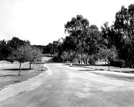
1976 BC Chapel drive viewed from the Chapel
Boys' College
Part of Boys' College and Boys' Prep photographs 1953 onwards
1976 BC Chapel drive viewed from the Chapel
Boys' College
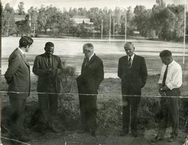
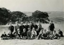
1969 BC Presentation of cattle Henning collection
Part of Boys' College and Boys' Prep photographs 1953 onwards
1969 BC Presentation of cattle Henning collection. The presenter, [...] was a local policeman who grazed his cattle on the school property in return for their use to pull the grass cutter. In this photograph he presents the College with an ox.
Legend:
Mark Henning, [...], Ray Bradley, Vernon Clegg, Lindsay Baytopp
Boys' College
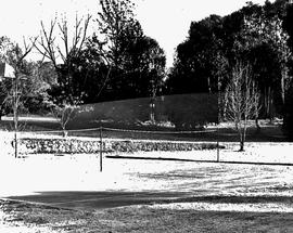
1967 BC Chapel lawns Badminton Court NIS TBI
Part of Boys' College and Boys' Prep photographs 1953 onwards
Badminton Court on BC Cheetah slopes close to Tennis courts. NIS TBI. Date is estimated to be circa 1967.
Boys' College
1965 Campus view to BC and Sandton
Part of Douglas Drysdale Fonds
1965 Campus view to BC and Sandton. The staff house closest to the squash courts can be seen under construction.
Drysdale, Douglas
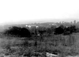
1965 BC view over BC to Sandton from the Koppie
Part of Boys' College and Boys' Prep photographs 1953 onwards
Landscape view showing the extent of the campus with the view to Sandton from the Koppie.
Boys' College
1964 Campus view from koppie area c.1964 NIS
Part of Boys' College and Boys' Prep photographs 1953 onwards
1964 Campus view from koppie area circa 1964 NIS.
Boys' College
1964 BC staff houses above pool circa 1964
Part of Boys' College and Boys' Prep photographs 1953 onwards
1964 BC staff houses above pool at the top of Chapel Drive. Photograph dated to circa 1964.
Boys' College
Part of Harris Fonds
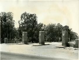
1961 HA 094 Corlett Gate viewed from the north
1957 HA 064 Campus aerial view
Part of Harris Fonds
1957 HA 064 Campus aerial view showing the extent of the College buildings and the ring road and the location of the original school gate close to the centre of Randburg.
1957 Campus view from koppie area 001 1957BC_0012
Part of Boys' College and Boys' Prep photographs 1953 onwards
1957 Campus view from koppie area 001
Unknown
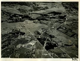
Part of Harris Fonds
1955 HA 032 Aerial photograph of the College grounds and surrounding areas taken from the north. The intersection of Main Road and the later-named William Nicol Highway can be clearly seen in the central axis of the photograph.
1955 Campus view from koppie 1955BC_0002
Part of Boys' College and Boys' Prep photographs 1953 onwards
1995 Campus view
Unknown
1955 Campus aerial view to South 1955BC_0003
Part of Boys' College and Boys' Prep photographs 1953 onwards
1995 First Aerial view of Campus in the Bryanston context. Many landmarks are recognisable in this photograph e.g. the Mount St Water tower; the Braamfontein Spruit and the intersection of Main Road and William Nicol before the establishment of the highway.
Unknown
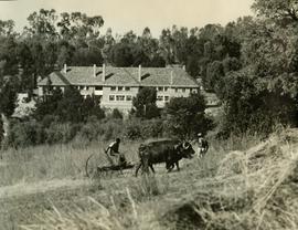
1954 HA 024 BC Mountstephens House with oxen
Part of Harris Fonds
1954 HA 024 BC Mountstephens House with oxen pulling the grass mower.
Unknown
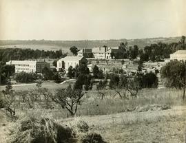
1954 HA 023 College buildings view to Sandton
Part of Harris Fonds
1954 HA 023 College buildings view to Sandton from orchard
Unknown
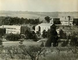
1954 HA 022 BC buildings from orchard
Part of Harris Fonds
1954 HA 022 BC buildings from orchard looking towards Sandton.
Unknown
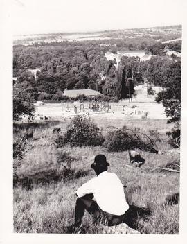
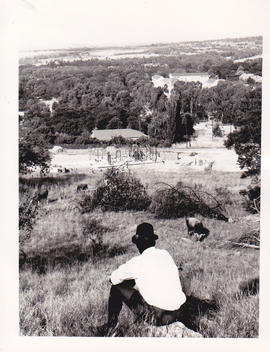
1953 BC Foundation scholars, view looking towards Sandton
Part of Doreen Read Fonds
1953 BC Foundation scholars, view looking across what was later to become the suburb of Parkmore, towards the ridge where Sandton City was built in 1973 on Zandfontein Farm.
This photograph illustrates the remoteness of the St Stithians property at the time the College was founded. The property, itself a portion of the original Driefontein Farm, was surrounded by farmland in 1953.
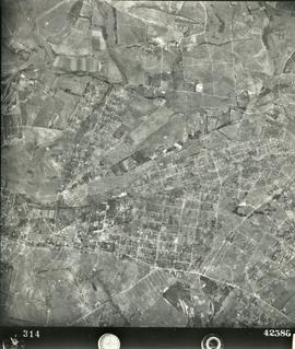
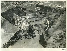
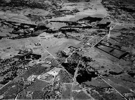
1952 Aerial photograph St Stithians Campus and surrounds 002
Part of Derek Kyle Fonds
Aerial photograph showing the campus and surrounding farming and peri-urban areas in 1952.
Aircraft Operating Company
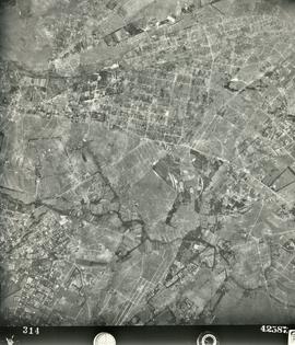
1952 Aerial photograph St Stithians Campus and surrounds 001
Part of Derek Kyle Fonds
Aerial photograph showing the campus and surrounding farming and peri-urban areas in 1952.
Aircraft Operating Company